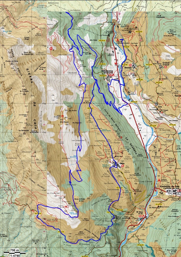
Route of 39 km and 1,800 m of unevenness that takes us to the easternmost part of the Sierra de Chía, to pass over it and jump to the congosto of the Ventamillo and return over it to Chía and descend by path very easy and enjoy camping …
Leaving the campsite we head south along the Esera river, until we reach the Sesué bridge. We cross it to go up to the town of Villanova and just before reaching the Town Hall, a forest track leaves on the left hand side (upwards) that after a descent connects with another one of climbing (immediately it is necessary to cross a barrier) and after some very strong ramps and After passing a flat area, another climb with a barrier, we are located on the track of the port of Sahún.
We take it downwards, so that when we reach a cattle trough in an area where the track is concreted, we take a forest track to the right ascending that after a long climb, we get to pass over the Sierra de Chia ( the views of the Cotiella and the Turbon are spectacular… ..).
We go down the southern side of the Sierra de Chia through an area of meadows in which the road is not very clear but it is not easy to get lost and we soon reach a forest track that we take to the left.
This track takes us to the town of Chia, we cross it in the direction of ascent and when we reach the last house of the town we take the path on the left (not the Plan track) and after some soft ramps (which seem strong for accusing the accumulated effort) we get back to the Plan track.
We cross it to take an exquisite path that leads us to the track that we have cycled a few hours before, we take it in the right direction (descending) and soon we reach the barrier, when crossing it we do not take the first turn to the left, if not the second which leads us to the Benasque road, from there to the Sesué bridge and from there only the last breath is left …… finally the campsite.
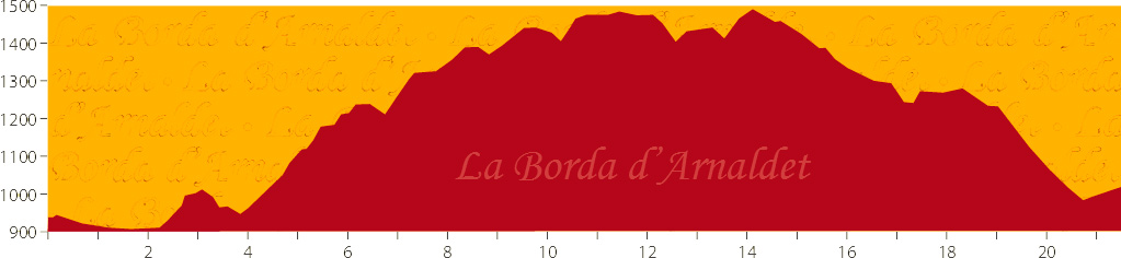
| Estimated time | 4 hours 30 minutes |
|---|---|
| Distance | 39 km. |
| Difficulty | Medium hard |
| Accumulated drop | 1800 m |
| Wikiloc | |
| Google Maps | |
| Download track | |
| Download the file |